Amsterdam's geological story begins millions of years ago during the Pleistocene epoch when the intricate interplay between ice and sea sculpted the region, creating sandy dunes along the coast and fertile polders in the heart of the city. Successively, after the ice retired, fluvial activity transported sediments all around, contributing to a landscape characterized by dunes and wetlands.
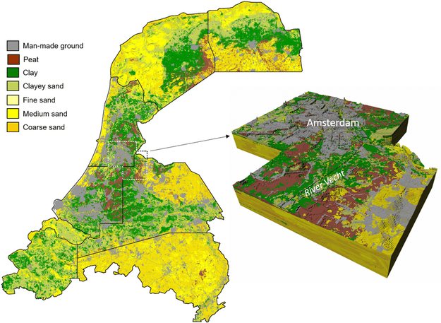
More specifically, Amsterdam's western part, including areas like Zandvoort and Haarlem, was shaped by the ebb and flow of the North Sea. Sand dunes were formed along the coast, creating an ecosystem that influences the flora in this area, with plants adapted to the sandy soil and salt-spraying.
The central and eastern parts of Amsterdam were once covered by vast peat bogs. As settlers reclaimed land for agriculture, polders emerged. The drained peat-rich soils, known as veengronden, are fertile and support a diverse range of vegetation. Today, these areas display a blend of wetland plants, adapted to the historical water management practices.
The southern parts of Amsterdam, near the Amstel River, are characterized by clay deposits. This area has been influenced by river dynamics, leading to a mix of clayey soils that support a variety of plant life. The interaction between the river and the landscape has created unique habitats for vegetation to thrive.
Let's dive into some post-classical history: around 800 AD the peatlands around Amstelland were drained by two rivers - basically, two sides of modern Amstel (hence the name). The ‘northern’ side discharged surplus water directly into Lake Almere. The ‘southern’ part was a near-abandoned westernmost arm of the River Vecht discharging the poorly drained borderland around the river Vecht into Lake Almere.
As part of the reclamation of peatlands associated with agricultural activities between the end of the 10th and the mid-13th centuries, the rivers were connected via a canal, thus creating the river Amstel, as it is known today.
This process started at the end of the 10th century and was completed by the end of the 13th century. Within these three centuries, the morphology of the peatlands changed considerably: peat domes and ridges, which reached around 4 m above sea level (the ‘Dutch mountains’ of the western Netherlands) completely disappeared, and catchment areas, watershed margins and river drainage all changed. Also, during the 12th century onwards, Lake Almere was enlarged to form the Sudersee (in Dutch: Zuiderzee).
Flash forward to the 19th and 20th centuries: the historical interventions and the construction of vital waterways, the Nieuwe Waterweg (1872, it connects Rotterdam to the North Sea) and the North Sea Canal (1876, from Amsterdam to the North Sea), signed a transformative period. These projects were crucial to safeguarding the port cities of Amsterdam and Rotterdam, altering the dynamics of sea influence.
The Nieuwe Waterweg was a lifeline for maritime trade, but introduced challenges. It remained open, allowing the inland influence of tides and salt to persist and grow. The sea, a force that once sculpted dunes, now asserted its influence further inland, impacting the delicate ecosystems shaped by centuries of geological evolution.
With the construction of the Afsluitdijk (1932, a 32 km long dam between Den Oever and Zurich), the salt content of the surface water in North Holland has decreased sharply. However, South Holland continued to grapple with salinization.
After the Flood (1953), the Delta Plan was established: it was a series of construction projects to protect a large area of land around the Rhine–Meuse–Scheldt delta from the sea. Constructed between 1954 and 1997, the works consist of dams, sluices, locks, dykes, levees, and storm surge barriers located in the provinces of South Holland and Zeeland. Both the Scheldt and the Nieuwe Waterweg remained in open connection with the sea. The area of influence of the sea therefore still shifts further inland.
This geological diversity has transformed Amsterdam -and the Netherlands in general- into a biodiversity hotspot, where the city's vegetation tells a story of adaptation and resilience: we find buckthorn, beach grasses, and various salt-tolerant shrubs on coastal dunes; sedges, reeds, and various wetland plants in peat bogs; willows, reed beds, and aquatic plants in river areas – not to mention ornamental plants and agricultural crops that dominate urban environment and polders.
This rich tapestry of flora is unfortunately challenged by urbanization and human activities. Also, the shifting balance between sea and land demands innovative conservation strategies. Efforts to sustain Amsterdam's biodiversity must now consider the evolving dynamics of sea influence. Integrating historical knowledge, geological insights, and the impact of sea influence on vegetation becomes imperative in crafting sustainable solutions for the future.